
Overview: Chitral is one of the mountain regions of Pakistan, lying in the extreme north. Its total area is 14800 km and 90% area is under mountains. The highest and most dense section of Hindu Kush lies within the borders of Chitral.
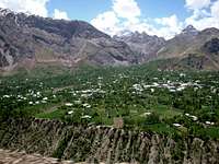
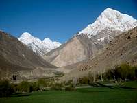
The Chitral valley, located in the northern region of Pakistan, is one of the most remarkable places in the world when it comes to natural scenic beauty. Its picturesque mountains, sulphur springs, Juniper forests, friendly people and rivers teeming with the famous Trout fish are truly spellbinding.
Chitral is also the most peaceful Region of Pakistan. Its culture is unique. There are two racial groups in Chitral. One is Kalash who are reported to be the descendants of Alexander the Great. The Kalash are now only about three thousand people and live in the southwest valleys of Chitral. They have their unique culture with three main festivals a year and a major source of tourist attraction. They live peacefully with their neighbors who outnumber them. Their ways of life are quite interesting. The other group living with their Kalash neighbors in a state of ideal friendship and harmony is called Kho who are reputed for their culture and peace loving nature and integrity. British and Chitrali writers have written many books in English on Kalash culture as well as on Chitral as a whole, and these books are available in major libraries, in the market as well as on the Net. Research on the history, origin and Culture of the Kalash community of Chitral is still in progress.
The Chitral valley is situated amidst the mighty mountains of the Hindukush range. This mountain range is 322 km long. The local language spoken in the Chitral valley is Khowar Language. Urdu, the national language of Pakistan, is also understood. The people of Kafir Kalash use their own language called the Kalashi language. The people of Chitral valley mostly wear "Shalwar Kameez" which is the national dress of Pakistan. Women wear "Duppatas" and Shawls along with "Shalwar Kameez". The most popular head dress of the Chitrali men is the woolen "Pakol". In winters, the men wear long baggy coats having long sleeves known as the "Shuqa". These coats are also made out of wool. The traditional sport of Chitral is Polo. World's highest Polo ground (Shandur Polo ground) is also present in this area, where the Shandur Polo festival takes place.
Tribes of Chitral
KhowThe Khow people of Chitral make majority of the population and hail not from one stock but belong to various ethnic groups who had reached Chitral in different waves of migration from more in hospitable valleys around the present district of Chitral. The original Khow people flourished in the Mulkhow and Torkhow valleys. In the former, a big flat rock, still called Khow boht, to be the seat of assembly where important issues of resource distribution and management were taken. The Khow then occupied the whole of upper Chitral and had their own principality one of whom was known as Bahmani Kohistani. The old Khow had later intermingled with the newcomers or we may rightly say the new comers adopted the ways of the old Khow and spread down wards till they reach the Chitral and ousted the kalash rulers and occupied the whole of Chitral. Khow are known as highly cultured, polite, honest, brave and martial people maintained the independent position of Chitral State for many centuries.
Kalash Tribe
The Kalash believe they are originally from Tsiam, although no one yet knows where that is. It is more likely they are descendants from Indo-Aryans (about 2000BC). Many historians believe the Kalash are descendants of the soldiers of Alexander the Great.
The kalash valleys of Rumbur, Bumburet and Birir are within Chitral District of Pakistan. The kalash people are the only non-Muslims for hundreds of miles. They may be a little wary of strangers, but usually do welcome who wants to become acquainted with the kalash way of life.
The 3500 Kalash of the valleys live in unique houses made of local stone and wood which are stacked on top of one another at steep hillsides. The roof of one house is the verandah of another, on top of the lower house. They make their living with staple crops like lentils or wheat and by goat herding. Life is very traditional, like in many parts of the world, and the work division between men and their women is elaborate. Family life, cattle herding and harvesting form their main livelihood with the occasional distraction of a festival or two. Women move into a Bashaleni house when giving birth and also when they are menstruating. Many aspects of the society are both communal and segregated and typically, marriages are made by arrangement.
Important Villages of Chitral

Terich Valley
Terich valley is populated with several small villages separated by groves of apricot and apple trees. The valley is very fertile and the resulting verdant floor is in breathtaking contrasts to orange and yellow apricots and apples, especially in late summer.
Terich valley- the main route to high Hindu Kush peaks and center of adventure tour activities- also has other good potential such as mineral deposits of yellow arsenic, serpentine, quartz, talc, calcite, antimony, gold dust etc. but mining is not yet in progress hence people have few jobs to earn their livelihood. Mostly people depend on subsistence farming and get food supply from government stores. Local sources of income are almost nil. In the past decades the people of this valley used to get good summer jobs on the arrival of mountaineering expeditions, trekkers, hikers and got handsome income. There used to be around a dozen or more adventure parties to climb the high peaks approaching through this valley. Evidently they needed porters; guides, high altitude porters, cooks etc and the local people got jobs for many weeks on good wages and had a coveted source of income beside other benefits on the return of those parties such as good tips, awards, surplus food items, kits etc. But now unfortunately the number of foreign trekking, hiking, climbing teams has declined as a result of Afghan war and also that Tour operators from Chitral have failed to enter Tourism markets to spread information and motivate adventure lovers, using various means of technology for promotion of trekking and climbing and other adventure activities in the Hindukush, this channel of summer income has declined and the local people face financial burden.
Terich valley a gateway to the major Mountaineering, Trekking and Hiking routes, which lead to the highest peaks and longest glaciers of the central Hindukush. Terich, which is one of Pakistan’s highest and remote valleys, the last human settlement before the actual march to Terich Glacier and Terich Concordia, Udren and Roshgol Glaciers. Its real attraction is being a gateway to the most spectacular sights of the region to Terich Concordia and Roshgol the amphitheatre of 7 highest massifs of Hindukush and the longest glaciers and peaks, including, Tirich Mir Main 7708m, Tirich Mir East 7690m, Noshaq Main 7492mm, Noshaq East 7480m, Istor o Nal 7403m, Saraghrar 7349m and Shingeik Zom 7290m.
Booni
Booni is now a Town and administration centre of the upper Chitral since 1969. It is a big fan shaped flat and big village, perhaps one of the largest villages of the area. It is famous for its fruits like; apples, pears, grapes, apricots, peaches etc. It lies at 72 km from Chitral Town on the Shandur-Gilgit road.
Garam Chashma
At a distance of 2 hours, is located the famous valley of Injigan, now called Garam Chashma, and could be approached by jeep, car etc. but better to be inside an open jeep to enjoy the scenic beauty enroute to the area while visiting the challenging and breath taking rocky spires of Shoghore and if one has the guts then some rock climbing could be done in the area, as it has become one of the favorite sport for rock climbing after the training camps of Adventure Foundation Pakistan for a couple of year ago. Garam Chashma, famous for its hot springs and the water is considered for centuries, as a natural medication to cure the skin disorders and maladies; therefore the valley is visited by local tourists as well as foreign during the season. Overnight stay at the valley could be one of the most amazing experiences while enjoying the serenity and peacefulness of the area, especially the beauty of the mountains and landscape may enchanter you. Don’t forget to obtain a permit from the fisheries department of Chitral before leaving for the valley, if you are interested in doing some angling in the Garam Chashma River and want to taste the trout.
Chitral Gol National Park
Chitral Gol National Park is one of the national parks of Pakistan. It is located in Chitral District in the NWFP of Pakistan beside the Chitral River, at a distance of two hours drive from Chitral city. The park is also known as Chitral Gol National Park. The word Gol in the local language means 'the valley'.The way leading to the park is quite narrow and dangerous, yet more risky during the rainy days. It is located between 1450 metres and about 5000 metres above sea level. It has an area of 77.5 square kilometers.
This park includes three valleys. Several Glaciers also lie in the park through which several springs make their way and ultimately form a stream of 18 metres. The cold water of this stream falls towards the east into the Chitral River. The park is rich in trees particularly Cedar trees. Chitral Gol National Park is surrounded by high Hindukush peaks and is a habitat of a number of wildlife like: Kashmir Markhor, Ibex, Snow Leopard, Lynx, Chakor, Ram Chakor, Pheasant, Himalayan Griffon Vultures, Golden Eagle, Himalayan Snowcock, Himalayan Monal Pheasants, and a large variety of birds and wild animals. National bird of Pakistan, Chakor, National animal, Markhor and National Tree, Diyar are also found in Chitral Gol National Park.
The annual rainfall in its region is estimated to be 462 ml. In September it rains more on the spectacular peaks surrounding the park. However, in November the rainfall is more in the valleys and on the lower peaks .There is also a session of snowfall during the winter season. The snow covered white peaks also enhance the beauty till June. After which it starts melting. The general weather is cold and dry. The temperature ranges from -12.2 to 43.3 °C.
Getting There
By AirPIA operates a daily flight (subject to weather conditions) between Islamabad to Chitral and one flight Peshawar to Chitral. The flying time is 60 minutes and 40 minutes respectively. Islamabad and Peshawar can be reached by air; rail and road from all the major cities of Pakistan. For flight enquiries in Chitral, please contact to PIA Booking office, Opposite Polo ground, Chitral.
By Road
Chitral is accessible from Peshawar by the 365km long partly metalled and partly gravel-top jeep-able road, which goes via Malakand, Director and the 3118 meters high Lowari Pass which is open during the summer months only, i.e from June to the end of October and may even close earlier due to an early snowfall. Chitral can also be reached from Gilgit via 3810 meters (12,500 feet) high Shandur Pass.
Festivals
Kalash FestivalsThe Kalash are famous for their festivals and dress code. They for example know how to let their hair down in style. There is much dancing where the elders chant legends with drum accompaniment and the women dance around in the open place. Locally brewed wine is drunk in copious quantities. The festival dates are only fixed to a certain extent as the people and the dates depend on the harvest.
The festival of Chilimjusht or Joshi is for spring harvest and last 4-6 days around mid May and the Uchal festival on 20th August celebrates the pre-harvest with cheese, corn and wine. Chitirmas in mid December celebrates the winter solstice and is the most impressive festival, lasting for up to 10 days.
The kalash worship many gods of Kafiristan like Balomain, the heroic demi-god of the kalash Balomain’s spirit is said to pass through the valley counting the people of Kalash and collecting their prayers to return them to Tsiam, the mythical land of the kalash.
The Kalash people thank the creator during their festivals. Each festival is meant to give thanks to the Almighty. The dancing is one way of showing happiness and thankfulness towards the Creator.
Much of the dancing take place in large circles around a bonfire and people chant with mesmerizing repetitions – with just a drum beat accompanying the voices. The girls wear intricate dresses made of cowry shells, coins and beads with beautiful hair braiding and headwear. Each heavy headdress weighing several pounds is presented to a girl by her uncle. The jewellery includes necklaces made from apricot kernels, a traditional gift during the festivals. Single women are expected to find themselves a husband during these festivals.
Just before the main festival, seasonal food is offered to the ancestral spirits and a kotik, light for the ancestors, is lit. After this ritual the food, considered impure, is offered to the elderly women to be eaten.
During the festival, purity is paramount and celibacy is enforced throughout the days of the event so all the people will have a pure mind when Balomain visit the valley. All people must clean themselves in a ritual bath the week before the festival begins. During the men’s purification ceremony, they may not sit down at all during the day and at night the blood of a sacrificed goat is sprinkled on their faces. Special bread is eaten, baked away from the main village, and prepared by men only during the purification ceremony. Another Bread, called jaou, is prepared for the festival and stuffed with crushed walnuts and goat cheese.
Special dance halls exist for the purpose of some of the dancing at festivals. They are decorated with carved and ornate wooden pillars and goat-like figurines. The music and dance is a performance of set songs: the cha or clapping song is the simplest one to a lilting dance, sung by the elders.
Chilimjusht or Joshi-Spring Festival (13-16 May)
This celebration is organized to pay thanks to the Almighty. The people celebrate the arrival of the spring season with new hopes and aspirations. Foreign and local tourists particularly schedule their visits in accordance with this festival, having specific aims to record various events of the festival.
Uchal- Summer Festival (20-22 August)
Kalash people organize Uchal, the harvest celebration to pay homage to the Almighty that blessed them with fruits and other crops. They prepare cheese, buttermilk and corn to celebrate this festival.
During the festival prayers, a procession is made to a high plateau outside the village in Balangkuru
where the long night of dancing begins. The festivals continue for many more days moving on to different locations within the valleys.
Chitirmas- Winter Festival (15th - 22nd December)
The festival is celebrated to welcome the arrival of the New Year. All the Kalash people remain indoors and outsiders are not allowed to enter their settlements for 7 days. The people have a merry time by free wine drinking and they sacrifice goats. People show their thanks by dancing and singing together, enjoying every moment
Shandur Polo Festival (7 -9 July)
The Shandur polo ground is in District Chitral. It is bordered on the West by Yarkhoon valley and on the Northern by the valley of Gilgit District. The polo ground is about 153 km away from the main Town Chitral and accessible by jeep. The road is closed during winter due to heavy snow.
The world famous Shandur Pass is about 3740m above sea level and lies midway between Chitral and Gilgit. The distance from Chitral is 153 km and Gilgit is about 211 km. These areas remain snow covered in winter and turn into a green heaven during the summer season. There is a big lake in the area.
Shandur is the highest and the largest polo ground in the world; there game of polo is played between teams from Chitral and Gilgit each year, 7-9th of July. The game originated in the dim and distant past in the high mountains of the Hindukush and Karakorum ranges. Amongst the horse loving-people of Chitral and Gilgit, here it is still played in its original form, a game that is tough, rough and hard both for man and horse, just as the surrounding mountains themselves. A game is without rules, a game with only a few pre-agreed conventions of play. Polo in Khowar Language is called “Istoorghar” and has been the traditional game of Chitral. The Motto is: We play polo as “the game of Kings and King of the games”. The game is commonly played to the music band comprising a big drum.
Wild Life In Chitral
Snow LeopardThe arrival of Snow Leopard in the vicinity of the villages Tooshi, and Terich valley, at the base of Roshgol valley, is an age long old phenomena where it announces its presence in December to February, on and off, as the higher parts of the hills are covered in deep snow and Snow Leopards know the route how to navigate the slopes in winters to avoid avalanche sites. It reports its arrival in the very cold season by its deep throated calls at night from certain ridges on its route, during it’s up or down journey, staying at its favorite spots for some days [usually they travel in twos] and frightening children by its calls at nights. Normally they don’t attack domestic animals but driven by hunger for longer period, they attack goats outside the villages. Mostly they get their food from the ibex flocks after stalking carefully. Regarding humans their behavior is very gentle.. they never attack humans even if they come across on the mountain tracks and there does not exist any such record of attack in the history of the region
The endangered snow leopard, ['purdom' in Khowar language], visits the Tooshi game reserve due to heavy snow and severe cold weather. The beautiful wild cat is normally seen in the game reserve mostly in winter as it comes there for at least four days to one week. During this time he feasts on a wild goat or two. Many local people and foreign tourists visit Tooshi to have a glimpse of the snow leopard.
Markhor
Markhor are an endangered species of wild goats whose range is mostly in Chitral- Pakistan. The males have beautiful horns which are serpentile shaped and can be very impressive.
Markhors are found throughout a number of areas within Northern and Western Pakistan but populations are low and localized. The only area where you are gauranteed to see Markhor is Tooshi Gol Game Reserve in Chitral which is about 30 minutes north of Chitral town. In the late afternoon until dusk, you will see Markhor descend the slopes to drink water from the passing river. It is possible to see upto 50 here and they seem in different to the watching humans.
This playful Markhor is friendly with people and sometimes keeps on awaiting for visitors to turn up, who hold him by the screwing big horns and play on the roadside at Tooshi, where the worth of one trophy hunt is USD 52000 to 80000. In winter the illusive snow leopard is also seen in the game reserve as it comes down near the riverbank chasing wild goats and Markhor.
Ibex
Ibex is found in the higher altitudes vs Markhor. In the past ibex hunting rules were strictly followed by the local hunters. Only good size male were their targets. Females and kids were left to grow and reproduce. Most valleys of Chitral were under state control. There is a wild life Deptt: of the Govt: of Pakistan tries to ensure the wild life population through its staff of wild life watchers but their efforts to control poaching is not very successful as the Number of the staff is small and the region is too large. Each year they carry out a census of the ibex population. Their habitats have been badly damaged due to over population, over grazing etc. Good size ibex are available for trophy hunting in various places of upper Chitral. Udren Gol, Atahk and Roshgol in Terich valley are famous for ibex habitats of Hindukush.
Mountaineering in Chitral Hindukush
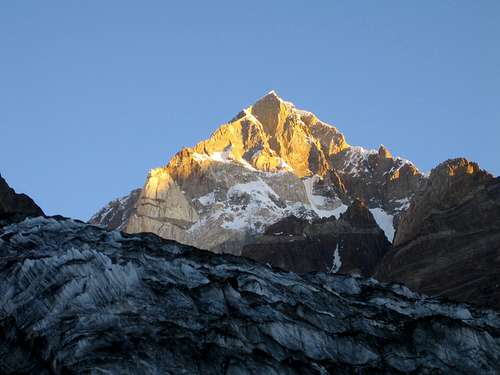
TEXT HERETirich Mir 7708mTirich Mir (alternatively) Terich Mir or Terichmir is a chain of several peaks; all above 7000m. Tirich Mir overlooks from Chitral town and can easily be seen from many villages of Chitral. Tirich Mir main 7708m is the highest peak in the whole of Hindukush mountain range of Chitral-Pakistan.
Other summits of Terich Mir group are:
Tirich Mir East 7690m
Tirich Mir West II 7500m
Tirich Mir West I 7487m
Tirich Mir West III 7400m
Tirich Mir West IV 7338m
Tirich Mir South 7100m
Tirich Mir North 7056m.
Tirich Mir main peak 7708m was climbed for the first time in 1950 by a Norwegian expedition led by Arne Naes, the famous Norwegian philosopher and writer, other members of the expedition were P.Kvern Berg and H.Berg.
Tirich Mir East 7690m was also first climbed by another Norwegian expedition in 1964.Two members of the expedition, R.Hoibakh and A.Opdal reached the top.
Tirich Mir West II 7500m was climbed by an Italian expedition; Beppe Re and Guido Machetto were reached the top in August 1974.
Tirich Mir West I 7487m was first climbed by a Czechoslovak expedition in July 1967, which was led by Engineer Vladimir Sedory, other members of the expedition were; Cervinka, I.Galfy, V.Smida and I.Urbanoric.The expedition did not use any oxygen nor did they fix ropes.
Tirich Mir West III 7400m was climbed in 1974 by Group University of Montagne et de Ski of France.The expedition was led by Guy Lucazeau and Bernard Amy.
Tirich Mir west IV 7338m, was first climbed in 1967 by well known Mountaineer of Austria Mr. Kurt Diemberger and DietmarProske to the very difficult route of north face.
The seventh peak of Tirich Mir group is Tirich Mir south, with an elevation of 7100m which is still unclimbed.
Tirich Mir North 7056m was climbed in 1965 by German- Austrian joint expedition, which was led by Kurt Diemberger; other members of the expedition were Herwig and Fritz Linder
Noshaq 7492m
Noshaq peak 7492m is an independent mountain on the border with Afghanistan and the 4th highest peak of the Hindukush range after Tirich Mir west II 7500m. Noshaq is located in the North Eastern border, which marks the border with Pakistan. Only the west peak, Noshaq West 7250m stands on the Pak-Afghan border, being natural water shed. Noshaq Main 7492m and the rest of the peaks of this massif lie well within Pakistan territory and easily accessible from Chitral-Pakistan.
Noshaq Main peak 4792m was first ascent by Japanese expedition in 1960.The expedition was led by Professor Sakato. Other members of the expedition were Goro Iwatsabo and Toshiaki Sakai. The route was followed from the South East Ridge of the peak, Nowadays; the normal route is by southeast face through Terich valley of Chitral-Pakistan.
The second highest peak in this range is Noshaq East 7480m climbed in 1963m by Dr.Gerald Gruber and Rudolf Pischenger from Austria. The 3rd highest peak of the massif Noshaq Central 7400m and the 4th peak is Noshaq West 7250m.
These peaks were also climbed by the same Austrian expedition of 1963.
The first winter ascent was in 1973 by Tadeusz Piotrowski and Andrzej Zawada, member of a Polish expedition, via the north face. It was the world’s first winter climb above any 7000m peak
Istor o Nal 7403m
Istor o Nal is the 3rd highest mountain in the High Hindu Kush range, in the Chitral District of Pakistan. It is the 68th highest independent peak in the world. It crowns a massif with 11 peaks of elevation more than 7000 m (22986ft). The peak is located a few kilometers north of Tirich Mir. Because Istor o Nal is behind the highest peak of Hindukush (Tirichmir 7708m) from many view points, it is not easily visible and therefore not well known.
The word “Istor o Nal” means horse shoe in the khowar language. Istor means “horse” and nal means “shoe” and the massif is look like a giant horse shoe.
Istor o Nal was first climbed on June 8, 1955 by the Americans Major Ken Bankwala, Josef E. Murphy, Jr, and Thomas A. Mutch, on a Princeton Mountaineering Club Expedition. They climbed the west ridge, starting from the south side of the peak through the Terich Glacier. Their small, minimally financed expedition (by the standards of the time for high altitude mountaineering) achieved what was then the second highest summit attained by Americans.
The main summit 7403m was climbed by a Spanish expedition in 1969 headed by Anglada. 2 of the 11 peaks are still unclimbed i.e. North East Peak 7276m and East Peak 7100m.
In the year 2000, a Swiss Expedition led by Simon Perritaz arranged an expedition for the unclimbed North East Peak 7276m with 8 other members; they could not gain the summit due to shortage of rope, time and mostly weather condition. The two peaks are still unclimbed and an obvious challenge for mountaineers.
Saraghrar 7349m
Saraghrar is a group of the 4th highest independent massif in the Hindu Kush mountain range of Chitral-Pakistan. The entire Saraghrar massif is a huge, irregular stretched plateau at elevation around 7000m (22966ft), lying above vertical granite and ice faces, which protect it all around. Its distinct summits are poorly identified, and information gathered from various expeditions that have visited the area is often misleading.
In 1958 a British Expedition led by Ted Norrish made a first try on the Main Summit 7349m. This expedition was stopped by the death of a member, P.S Nelson.
The year after, on August, 24th 1959, the North and the Main Summit 7349m were climbed for the 1st time by an Italian expedition led by Fosco Maraini, including Franco Alletto, Giancarlo Castelli, Paolo Consiglio and Professor Carlo Alberto Pinelli. Their route ascended via the Niroghi Glacier on the North East of the massif.
On August 24th 1967, Satoh Yukitoshi and Hara Hirosada, member of a Japanese expedition led by Kenichiro (Mountaineering Club of Hitotsubashi University) reached the South Summit 7307m for the first time by the Rosh-Gol Glacier.
In 1971, Nagano, member of a Japanese expedition (Shizuoka Climbing Club) led by Akiyama Reiski, climbed the South West peak 7184m for the first time on July 29th.
Two Catalan expeditions in 1975and 1977 tried the North West I summit 7300m via a rocky route, through the Roshgol (Terich valley) side but they did not reach the top.
On August, 1982, another Catalan Expedition, led by Juan Lopez, other members Enrique Lucas Liop Nil Bohigas Martorell reached up to 7200m the North West II summit (7250m)
In 2005, 5 members of a Swiss Expedition from (Neuchatel Mountaineering Club) led by Jean Michel Zweiacker reached the South East summit 7208m for the first time (Mazal Chevallier, Sebastian Grosjean and Yves-Alain Peter on July 24th: Marc Belanger and Jean Michel Zweiacker on July 29th) via South face. This route is the easiest one to any > 7000m peak in the region. It is known to be the safest route and also easy to access i.e. only 2 days trek to the Base Camp.
Todate 2005, there are 13 peaks of this massif are explored, all above 7000m. 6 of the 13 are still unclimbed- including the Central peak 7330m.
Unclimbed Peaks of Saraghrar Massif
Saraghrar Central …………….7330m
Saraghrar North West I…….... 7300m
Saraghrar South III …………..7280m
Saraghrar North West II ……..7250m
Saraghrar South East II ……...7185m
Saraghrar South II …………......7109m
Buni Zom
Buni Zom group is a prominent mountain area of Chitral, in the Hindukush Range of Pakistan. It rises about 50km North East of the town of Chitral, and about 50km East of Terichmir 7708m, the highest peak of Hindukush.
In 1957, the New Zealanders W.K.A Berry and C.H. Tyndale-Biscoe accomplished the first ascent of the main peak of Buni Zom 655m from the steep razor like North ridge. The second ascent was in 1975 by Japanese Masao Okabe, Hideo Sato and Shigero Tabe and third ascent was in 1979 by Americans Joe Reinhards and Richard J. Iaherwood both from South face.
In 2007, a Greek expedition, led by Nikolas Kroupis summitted an unclimbed peak of Buni Zom South or 6MT peak-6110m.
The Buni Zom group has many other peaks, some of which have been climbed. There are 12 peaks over 6000m (19700) ft in the Buni Zom group which are still unclimbed.
 |
Langutai-Barfi [7017m] unclimbed
Called the ‘ bride of the Hindukush’ lies at the end f Roshgol valley, Chitral. It is at 2 day trek from jeep road [ and this is a very plus point of Roshgol peaks] with one night at Duru camp [3300m] under birch trees and an ice cold spring.
This peak has never been climbed from the Roshgol [south] face because much higher peaks of the Roshgol amphitheatre downsize its height. Its south face is also fit for snow boarding over its 1500m gradient, just like the south face of Mt. Saraghrar where a climber of 2005 Swiss Expedition did snow barding from 6400m down to 4500m. .Langutai –Barfi’s wide south face has rock steps at convenient and safe grades to ascend to its east shoulder at 6500m [ also the upper limit for trekking under the mountaineering, trekking rules of the Ministry of Tourism, Govt. of Pakistan.] Chitral is one of the most peaceful regions of Pakistan and adventure tour to this peak or any other in this section of High Hindu Kush will be a pleasant experience. Local guides, high altitude porters,low and high altitude porters are available at very reasonable rate.
Burishomo Zom [6392m] unclimbed
This beautiful virgin peak is in the Roshgol valley of Chitral at 1 day trek from jeep road. Its north-east face presents a good ridge for climbing without any risk of rock fall or avalanche threats. At two points short rope fixing would enable climbers to reach the summit which has never been attempted. From Duru camp [3300m] the climbers will cross the river by a bridge and trek over meadows and scree to the base of the peak. Because of its proximity to nearby village supply of fresh edibles is easy. At about 5600m there is a fine snowboarding site of more than 600m with easy gradient. This peak is flanked by another higher virgin peak of 6650m to its north and a 6100m virgin peak to it south and another 5800m virgin peak of technical position for rock climbers lies to its east-all to be approached from one Base Camp.
PRECHU ZOM 1 [6100M] UNCLIMBED
This beautiful peak is situated in the Roshgol valley of Terich, Chitral- one of the unclimbed subsidiary peaks of the east ridge of Saraghrar massif. It has never been approached by trekker s or a climber as it has never been publicized. It lies at 2 day trek from jeep road and has easy slope with longer snow filed on all side so snow / ice climbing is the option. There is no rock face to be tackled.
One may start from Chitral for Zondrangram, a drive of 5-6 hour and stay at Terich Mir Guest house-camping. Get acclimatized and hire porters and a local guide. In 7-8 hours you will be at Duru camp [3300m]. From this camp you take an easterly stream-Warsinj stream- and camp after about 6-7 hour on a morain, just at the base of the glacier, 4500m. From here you may reach the PANORAMA POINT which gives you a commanding view of 7 valleys of high Hindu Kush, an unforgettable experience. From this point you may select your route over the snow field to Prechu Zom and may also scale Sucai Zom, 5980m, another attraction of the same vicinity. The Panorama point gives you options to the above peaks if you take the right side track and it also leads to Datti Zom massif,6247m, if you take the left side ridge. For novice climbers this vast plateau with a number of domed low peaks is ideal destination.
DATTI ZOM MASSIF[4Peaks]6000m-6247
From the Duru camp the same route as the Prechu Zom trek through pastures along the Warsinj stream and to the PANORAMA POINT. Here you take the left [ west] ridge and ascend gently to Datti Zom # 1, 6030m in about 3 hours. For novice climbers this is enough to get acclimatized here for more than one day. You may ascend the next peak the following day over the same ridge and summit the next peak of the ridge i.e. 6100m. The same ridge will be your guiding line for the other two peaks of the same massif if you have more days. Trekking limit is 6500m. supplies from the nearest village [Zondrangram] is easy and risk free.
NOBAISUN ZOM –THREE PEAKS,UNCLIMBED [ 6550m-6650m]
This vertical wall of three distinct peaks stands to the n-west of Burishomo Zom in the Roshgol valley of Hindukush to be approached from the Duru camping site but this is more difficult than other smaller peaks of the same valley. From jeep road it is at one day trek. Organisation of porters and logistics is easy and reasonable. It has never been attempted by any party.
Fresh supplies available at short notice.
PRECHU ZOM 2 [6060M] UNCLIMBED
This peak lies to the east of # 1 and is more technical. It has never been approached by any climber. The region around it is a high plateau and will need good amount of ropes to be fixed. It is also at 2 day trek from the jeep road of Terich valley , You may stay at Terich Mir Guest House/Camping and get a local guide and porters . The next day you will be at the Prechu fall after 5-6 hr and camp there. From this point 100m ascend will lead you into a valley with the target peak standing at some distance. Camp at the base of the glacier and explore the whole region to find the safest access to the bottom of the peak. Dozens of other <6000m unclimbed peaks surround this plateau. Porters, guide, food supply and all other services are easily available.
Mountains and Peaks
TEXT HEREb>7000m Peaks in Chitral-HindukushName Hights M Range Area Country 1st Ascent
Tirich Mir Main 7708m Hindukush Chitral Pakistan 1950
Tirich Mir East 7692m Hindukush Chitral Pakista 1964
Tirich Mir W II 7500m Hindukush Chitral Pakistan 1974
Noshaq Main 7492m Hindukush Chitral Pakistan 1960
Tirich Mir W I 7487m Hindukush Chitral Pakistan 1967
Noshaq East 7480m Hindukush Chitral Pakistan 1963
Istor o Nal Main 7403m Hindukush Chitral Pakistan 1969
Tirich Mir W III 7400m Hindukush Chitral Pakistan 1974
Noshaq Central 7400m Hindukush Chitral Pakistan 1963
Istor o Nal North 7373m Hindukush Chitral Pakistan 1955
Istor o Nal SE 7365m Hindukush Chitral Pakistan 1969
Noshaq West 7350m Hindukush Chitral Pakistan 1963
Saraghrar Main 7349m Hindukush Chitral Pakistan 1959
Tirich Mir W IV 7338m Hindukush Chitral Pakistan 1967
Saraghrar Central 7330m Hindukush Chitral Pakistan Unclimbed
Saraghrar South I 7307m Hindukush Chitral Pakistan 1967
Istor o Nal South 7303m Hindukush Chitral Pakistan 1969
Saraghrar NW I 7300m Hindukush Chitral Pakistan Unclimbed
Shingeik Zom 7291m Hindukush Chitral Pakistan 1966
Istor o Nal West 7280m Hindukush Chitral Pakistan 1975
Istor o Nal NE 7276m Hindukush Chitral Pakistan Unclimbed
Darban Zom 7219m Hindukush Chitral Pakistan 1965
Saraghrar SE 7208m Hindukush Chitral Pakistan 2005
Saraghrar NW II 7250m Hindukush Chitral Pakistan Unclimbed
Udren Zom I 7131m Hindukush Chitral Pakistan 1965
Shakawar Peak 7116m Hindukush Chitral Pakistan 1964
Udren Zom II 7112m Hindukush Chitral Pakistan 1964
Tirich Mir South 7100m Hindukush Chitral Pakistan Unclimbed
Istor o Nal East 7100m Hindukush Chitral Pakistan Unclimbed
Nobaisun Zom 7070m Hindukush Chitral Pakistan 1967
Langar Zom I 7070m Hindukush Chitral Pakistan Unclimbed
Udren Zom South 7050m Hindukush Chitral Pakistan Climbed
Saraghrar North 7040m Hindukush Chitral Pakistan 1959
Koh-e-Urgend 7038m Hindukush Chitral Pakistan 1963
Akhir Shakh 7020m Hindukush Chitral Pakistan 1966
Langutai Barfi 7017m Hindukush Chitral Pakistan Unclimbed
Koh-e-Tez 7015m Hindukush Chitral PakistanClimbed
Langar Zom II 7015m Hindukush Chitral Pakistan 1964
Saraghrar SE II 7185m Hindukush Chitral Pakistan Unclimbed
Saraghrar S II 7109m Hindukush Chitral Pakistan Unclimbed
Saraghrar S III 7280m Hindukush Chitral Pakistan Unclimbed
7000m Peaks (Unclimbed)
Name Altitude Range Area Country 1st Ascent
Saraghrar Central 7330m Hindukush Chitral Pakistan Unclimbed
Saraghrar NWI 7300m Hindukush Chitral Pakistan Unclimbed
Istor o Nal NE 7276m Hindukush Chitral Pakistan Unclimbed
Saraghrar NWII 7250m Hindukush Chitral Pakistan Unclimbed
Saraghrar SE II 7184m Hindukush Chitral Pakistan Unclimbed
Tirich Mir South 7100m Hindukush Chitral Pakista Unclimbed
Istor o Nal East 7100m Hindukush Chitral Pakistan Unclimbed
Langutai Barfi 7017m Hindukush Chitral Pakista Unclimbed
Saraghrar S II 7109m Hindukush Chitral Pakistan Unclimbed Saraghrar S III 7280m Hindukush Chitral Pakistan Unclimbed
Best Season
Best season of visit to Chitral from April to December, but for watching Snow leopard, Markhor and other wild life it is recommended to visit from mid December to end of February.For further information, Travel and support, please contact us:
E-mail: Razaq@terichmirtravel.com
terichmirtravel@yahoo.com
Cell: 0092 345 8746424
Weather
Chitral and most of Hindu Kush region gets rains in winter, from December to April and after that Chitral enjoys fine dry weather because the monsoon clouds don’t reach this part of Asia so adventure tourism has got the best conditions for people who visit from Europe during their summer vacations. This dry summer of Chitral has enabled climbers and Para gliders to enjoy the best opportunities and that is why most of the mountaineering expeditions are usually successful. Paragliding is ideal even in October from the Zani Pass launching pad, which is approached by jeep or by trek.Natural Lakes in Chitral
There are a number of lakes in Chitral, mostly at great heights and ideal for trekking destinations Karambar Lake, in the eastern tip of Chitral boundary to the east of Boroghil pass. Shandur Lake on top of Shandur pass is easily approached by jeep, is also known for the polo festival in July each summer. Another lake is Bashqargolo chat lies in the same region. There is a large glacial lake on the route to Udren pass at 4000m and another lies at the end of Roshgol glacier, at the base of Langar Zom south, in the Roshgol valley.Shordonik, Bawansoor and Ochensoor are located on the Terich Aan ridge to be approached via Zani pass, by jeep. Another lake lies in the Uzhnugol at Utakh. Another lake is situated at the base of Istor o Nal east, a few km from Shughur baisun camp in the lower Terich glacier. These are major attraction but there are hundreds of smaller glacial lakes in the main glacial section of the high Hindu Kush.
External Links
Local Information, Travel inquiry and Supportwww.terichmirtravel.com
A Greek Scholar, Mountaineer and Explorer
Dr. Nikolas Kroupis
Research work on Hindukush Mountains and Cultures
www.hindukushadventureguides.com
[img::alignleft:small:]
Source : http://www.summitpost.org/chitral-a-hidden-paradise-on-earth/556309


0 Comments